


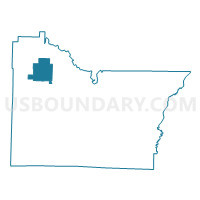
ANNIEVILLE Voting District, Lawrence County, Arkansas
About
Outline

Summary
| Unique Area Identifier | 527042 |
| Name | ANNIEVILLE Voting District |
| County | Lawrence County |
| State | Arkansas |
| Area (square miles) | 14.25 |
| Land Area (square miles) | 14.16 |
| Water Area (square miles) | 0.09 |
| % of Land Area | 99.36 |
| % of Water Area | 0.64 |
| Latitude of the Internal Point | 36.14792920 |
| Longtitude of the Internal Point | -91.24945670 |
Maps

Graphs
Select a template below for downloading or customizing gragh for ANNIEVILLE Voting District, Lawrence County, Arkansas


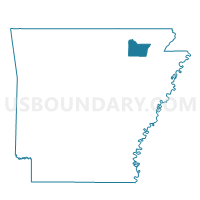
Neighbors
Neighoring Voting District (by Name) Neighboring Voting District on the Map
- DENT Voting District, Lawrence County, AR
- FLAT CREEK Voting District, Lawrence County, AR
- SPRING RIVER Voting District, Lawrence County, AR
- STRAWBERRY Voting District, Lawrence County, AR
Top 10 Neighboring County Subdivision (by Population) Neighboring County Subdivision on the Map
- Dent township, Lawrence County, AR (1,009)
- Annieville township, Lawrence County, AR (409)
- Strawberry township, Lawrence County, AR (374)
- Spring River township, Lawrence County, AR (374)
- Flat Creek township, Lawrence County, AR (128)